
🦅 SenseFly eBee X Drone: The Ultimate Guide to Professional Mapping and Surveying 🌍✨
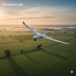
In today’s fast-paced, data-driven world, professionals in surveying, agriculture, construction, mining, and environmental monitoring need drones that combine accuracy, efficiency, and reliability. The SenseFly eBee X is a fixed-wing drone that has emerged as a leader in professional aerial mapping.
Unlike typical multi-rotor drones that hover and consume energy quickly, the eBee X flies like a lightweight airplane, providing long endurance, large-area coverage, and unmatched survey-grade precision. 🚁
This comprehensive guide covers everything you need to know: battery, specifications, user manual, app integration, real user reviews, pros & cons, applications, and more — with answers to all the frequently searched questions online.
⚙️ What Is the SenseFly eBee X?
The SenseFly eBee X is a professional fixed-wing mapping drone designed for large-scale surveying, precise mapping, and industrial applications.
Key industries leveraging the eBee X include:
-
🌾 Agriculture: Crop analysis, NDVI imaging, and irrigation management
-
🏗️ Construction & Infrastructure: 3D site modeling and progress monitoring
-
⛏️ Mining & Quarrying: Terrain modeling, stockpile calculations, and safety inspections
-
🌲 Environmental Monitoring: Forest surveys, wildlife mapping, and coastal erosion monitoring
-
🚨 Disaster Management: Quick assessment of emergency zones and rescue planning
Unlike quadcopters that hover in place, the fixed-wing design allows the eBee X to fly longer distances efficiently, covering hundreds of hectares in a single flight. Its lightweight yet durable frame, combined with professional-grade sensors, makes it the perfect choice for industries where precision and efficiency are critical.
🔋 SenseFly eBee X Battery – Long Flight Time for Maximum Productivity
One of the eBee X’s most impressive features is its long-lasting battery system, which allows professionals to cover large areas without constant interruptions.
Key Battery Features:
-
Endurance Extension Battery: Allows flights up to 90 minutes, significantly reducing downtime ⏱️
-
Removable Li-ion battery packs: Easy to swap in the field for back-to-back missions 🔄
-
Smart battery management: Monitors charge level, temperature, and overall health to ensure safe operations 🔋
-
Lightweight yet powerful: Maintains drone’s portability without compromising flight efficiency ⚡
Real-World Flight Time:
-
80–85% of maximum flight time in normal conditions (wind, payload, altitude can affect performance)
-
Enough to map up to 500 hectares in one flight — ideal for large farms, construction sites, or environmental surveys 🌾
Tips for Optimal Battery Life:
-
Fully charge the battery before the first flight.
-
Avoid flying in extreme cold or hot temperatures to preserve battery health ❄️☀️
-
Use the app’s battery monitoring feature for real-time updates.
-
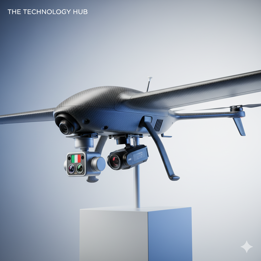
SenseFly eBee X drone
📘 SenseFly eBee X User Manual & Getting Started
The user manual is essential for safe and effective operation. It provides step-by-step guidance for beginners and professionals alike.
Key Sections of the User Manual:
-
Battery Installation & Safety Guidelines 🔋
-
Pre-Flight Checks ✅
-
Hand Launching Procedures ✈️
-
Landing Techniques 🛬
-
Payload Installation & Calibration 📸
-
Using the eMotion App for Mission Planning 🖥️
-
Maintenance & Troubleshooting 🛠️
You can download the SenseFly eBee X manual from the official SenseFly website or through the eMotion software.
Tip: Carefully reading the manual ensures maximum safety, optimal flight performance, and longer drone lifespan.
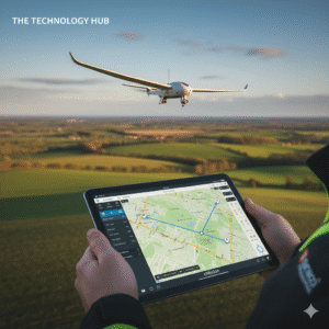
📱 SenseFly eBee X App – eMotion Software for Precision Control
The eMotion flight software is the heart of the eBee X experience. It’s available on Windows and tablet devices and allows users to plan, monitor, and control their drone missions efficiently.
Key Features of the App:
-
Mission Planning: Draw boundaries, set flight altitude, and define camera overlap ✏️
-
Real-Time Telemetry: Monitor battery, speed, altitude, GPS signal, and wind conditions 🛰️
-
Automated Flight Control: Takeoff, navigation, and landing are fully automated
-
Data Integration: Export captured images for 3D mapping, NDVI analysis, or orthomosaic generation 🌍
-
Flight History & Reports: Store previous missions and analyze flight data for optimization
The eMotion app makes the eBee X accessible to beginners while providing advanced options for experienced surveyors. Professionals appreciate its user-friendly interface and mission planning precision.
📝sensefly vs Specifications
Here’s a detailed breakdown of the drone’s specifications, making it easy to understand why it’s trusted by professionals worldwide:
| Feature | Specification |
|---|---|
| Wingspan | 116 cm (45.7 in) |
| Weight | 1.3–1.6 kg depending on payload |
| Max Flight Time | 90 minutes (Endurance Extension battery) |
| Coverage per Flight | Up to 500 hectares (1,235 acres) at 122 m altitude |
| Max Speed | 110 km/h (68 mph) |
| Cruising Speed | 40–90 km/h |
| Camera & Payload Options | RGB, multispectral (Sequoia+), thermal (Duet T), S.O.D.A. 3D |
| Accuracy (RTK/PPK) | 1.5 cm horizontal, 3 cm vertical |
| Launch Method | Hand launch, no runway needed |
| Landing | Linear or circular auto-landing |
| Control Range | Up to 8 km line of sight |
| Operating Temperature | −10 °C to +40 °C |
| Battery Type | Removable smart Li-ion polymer pack |
These specs show that the eBee X is built for endurance, precision, and professional applications — ideal for industries requiring large-scale mapping and high accuracy.

🏆 SenseFly eBee X Review – What Professionals Are Saying
Professionals across industries have praised the eBee X for its efficiency, accuracy, and versatility. Here’s a summary based on real user feedback:
🌟 Pros:
-
Unmatched Flight Time: Up to 90 minutes, covering huge areas in a single mission
-
Survey-Grade Accuracy: Centimeter-level precision with RTK/PPK
-
Versatile Payloads: Supports RGB, thermal, multispectral, and 3D mapping cameras
-
Lightweight & Portable: Fits in a backpack for field missions 🎒
-
Intuitive App Control: Easy flight planning with eMotion software
-
Durable & Reliable: Performs well in moderate weather conditions
⚠️ Cons:
-
Cannot Hover: Fixed-wing design means it’s not suitable for close-up inspections
-
High Initial Investment: Enterprise-grade drone with professional pricing 💰
-
Open Space Required: Needs space for hand launch and linear landing
-
Weather Sensitivity: Wind and rain can affect flight stability and mapping quality
Overall Verdict:
The SenseFly eBee X is considered a game-changer for professional mapping, surveying, agriculture, and industrial applications. Its combination of flight endurance, precision, and versatility makes it a top choice for professionals.
🌾 Applications of the SenseFly eBee X Drone
The eBee X is versatile and used across multiple industries.
1️⃣ Agriculture & Farming
-
Multispectral imaging for crop analysis
-
NDVI mapping to monitor plant health
-
Precision irrigation and fertilizer planning 🌱
2️⃣ Construction & Infrastructure
-
Track site progress with 3D mapping
-
Generate topographic maps and orthomosaics 🏗️
-
Calculate stockpile volumes accurately
3️⃣ Environmental Monitoring & Conservation
-
Track deforestation and forest coverage 🌲
-
Map wildlife habitats and wetlands
-
Monitor erosion and coastline changes
4️⃣ Mining & Quarrying
-
Terrain modeling for excavation planning ⛏️
-
Volume measurement of stockpiles
-
Monitor safety zones and site compliance
5️⃣ Emergency & Disaster Response
-
Map disaster-hit areas quickly 🚨
-
Support emergency rescue planning with real-time aerial data
-
Evaluate damage for efficient resource deployment
🌈 Why the eBee X Is a Must-Have for Professionals 🦅✨
The SenseFly eBee X is more than a drone — it’s a precision aerial mapping tool designed for professionals.
Key highlights:
-
Up to 90-minute flight time for maximum coverage 🔋
-
Modular payloads for RGB, thermal, multispectral, and 3D mapping 📸
-
RTK/PPK survey-grade accuracy 🛰️
-
eMotion app for easy planning and mission execution 📱
-
Lightweight and portable design for field use 🎒
Whether you’re in agriculture, construction, mining, or environmental research, the eBee X offers efficiency, accuracy, and reliability that no other fixed-wing drone in its class can match.
🔍 Frequently Asked Questions (FAQs)
💬 1. How long does the SenseFly eBee X battery last?
The eBee X can fly for up to 90 minutes using the Endurance Extension battery, making it one of the longest-lasting drones in its category. ⏱️ This allows you to cover hundreds of hectares in a single flight, reducing the need for multiple launches. Keep in mind that flight time can vary depending on wind conditions, payload weight, altitude, and temperature. For best results, always monitor battery status via the eMotion app and carry spare batteries for extended missions. 🔋
💬 2. Where can I download the SenseFly eBee X manual?
The official SenseFly eBee X manual can be downloaded from the SenseFly website or accessed directly through the eMotion flight software. 📘 The manual includes detailed instructions for pre-flight setup, hand-launching, landing procedures, payload installation, and troubleshooting. Beginners should read it carefully, while professionals can use it as a reference guide for advanced flight planning and maintenance tips.
💬 3. What cameras does the eBee X support?
The eBee X is highly versatile and supports multiple payloads to meet different industry needs:
-
RGB camera for standard mapping and photogrammetry 📸
-
Multispectral Sequoia+ camera for precision agriculture 🌱
-
Thermal Duet T camera for energy inspections and search/rescue 🔥
-
S.O.D.A. 3D camera for oblique imagery and 3D modeling 🏗️
This modular system allows users to swap cameras depending on the mission, making the eBee X suitable for construction, mining, agriculture, and environmental monitoring.
💬 4. Is the eBee X easy to fly?
Yes! Even beginners can operate it safely thanks to the eMotion flight planning software. 🖥️ Simply plan your mission by drawing boundaries, setting flight altitude, and defining camera overlap — the drone will handle automatic takeoff, navigation, and landing. Experienced users can also fine-tune flight paths, camera settings, and sensor configurations for highly specialized mapping tasks.
💬 5. Can it hover?
No. The eBee X is a fixed-wing drone, which means it cannot hover like quadcopters do. ❌ It’s designed for fast, long-distance flight and covering large areas efficiently. If your mission requires hovering — for inspections, cinematic shots, or close-up monitoring — a quadcopter like the Parrot Anafi or DJI Mavic 3 Enterprise is a better option.
💬 6. How accurate is the mapping?
With RTK/PPK technology, the eBee X can achieve centimeter-level accuracy:
-
Horizontal: ~1.5 cm
-
Vertical: ~3 cm 📐
This level of precision makes it ideal for professional applications, including surveying, construction, and agricultural monitoring. Even in challenging terrain or when mapping large areas, the eBee X maintains high consistency and reliable georeferencing.
💬 7. Is the SenseFly eBee X suitable for professional use?
Absolutely! 🌟 The eBee X is trusted by surveyors, engineers, agronomists, government agencies, and environmental scientists worldwide. Its long endurance, professional-grade sensors, and modular payloads make it a must-have for anyone needing accurate and efficient aerial mapping.
Professionals praise it for:
-
Covering large areas quickly, saving time and resources ⏱️
-
Reducing the need for ground-based measurements
-
Producing high-quality, survey-grade data compatible with GIS software like Pix4D, Agisoft Metashape, and ArcGIS 🌍
-
Operating safely in remote and challenging locations
Whether you’re a seasoned professional or just starting in aerial surveying, the eBee X is designed to streamline workflows and deliver reliable results every time. ✅